Skip to Content
 

European map: small countries and obstructive pieces

22 replies [Last post]
SLiV
SLiV's picture
Offline
Joined: 10/21/2011

Hey folks,

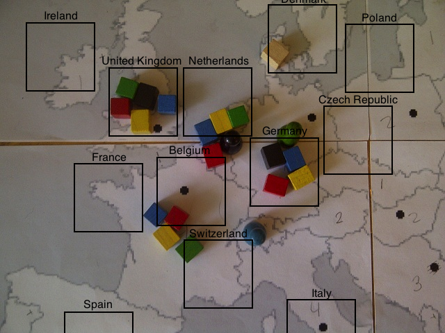
I am working on a (prototype) gameboard for a casual game I am developping. The board is a slightly modified but generally accurate map of Europe, and players go from country to country, collecting packages. There were two minor problems we encountered while playing, and I'm wondering if and how I should fix them.

One thing is that some countries (e.g. the Netherlands, Hungary and Israel) are a bit too small to fit all the pieces properly. We usually end up putting some pieces in the sea, but that causes a bit of confusion as to whether they belong to country A or country B.

Another problem is that the packages and pieces are often placed somewhere in the center of the country, but this is also where the values of the countries are put; this then obstructs these values, and pieces sometimes have to be moved by unexperienced players (which in this state of development is everybody, of course).

Two pictures for your explanatory comfort:
https://dl.dropbox.com/u/3757149/andere%20uploads/europe_oldmap1.jpg
https://dl.dropbox.com/u/3757149/andere%20uploads/europe_oldmap2.jpg

I have added a tiny bit of tampering, i.e. shifting a border a bit to the right to get some more space, but overall the map looks accurate. I thought of increasing the size of the smaller countries while keeping their original shape the same, but reckoned it would just look ridiculous.

What do you think? Should I sack the accuracy of the map in favor of a more fair space distribution? (I believe Risk's board does this, where continents are very close together and asia is compressed to fit the square boardsize.)

Also, in what other ways could I indicate the value of a country (which ranges from 1 to 6)? I thought of color coding, but that would require thicker borders (using a four-color scheme instead of thick black borders seems more comfortable), and it still would require people to remember which color is which.
Or is occasionally moving pieces to look at the board not that big a deal?

Taffer
Taffer's picture
Offline
Joined: 04/14/2012
"Another problem is that the

"Another problem is that the packages and pieces are often placed somewhere in the center of the country, but this is also where the values of the countries are put"

Easy solution: don't put the values in the center! Maybe on the top side instead, or "attached" to borders.

Sorry, don't have good advice about the other things. Maybe just make the smaller countries a different color and say they are not playable, just for decoration (on the other hand, I would probably dislike it if that happened to my country - Estonia).
Perhaps draw sea borders where part of a sea clearly belongs to one country.

SLiV
SLiV's picture
Offline
Joined: 10/21/2011
For gameplay sake, most small

For gameplay sake, most small countries have been annexed by other countries (e.g. Belgium and Luxembourg are part of the Netherlands, Libanon and Palestina are part of Israel etc); those small clusters of countries would make the game unplayable. (I'm afraid Estonia is also one of the victims; it's part of 'the Baltics'.)

However, those small annexated areas are still not big enough for the values to be fully visible when there's a pile of tokens stacked on them.

Taffer
Taffer's picture
Offline
Joined: 04/14/2012
SLiV wrote:(I'm afraid

SLiV wrote:
(I'm afraid Estonia is also one of the victims; it's part of 'the Baltics'.)

haha, that was going to be my next solution :)
SLiV wrote:
However, those small annexated areas are still not big enough for the values to be fully visible when there's a pile of tokens stacked on them.

But if you put the values near the borders?

SLiV
SLiV's picture
Offline
Joined: 10/21/2011
Border style

Well, since Israel is a long thin country, it already is near the border.

Perhaps I could add some meaning to the border itself, i.e. double lines for 2, triple for 3, thick line for 4, etc? Not even instead, but just in addition to the numbers.

Gizensha
Offline
Joined: 07/26/2008
What about 'cutaway' boxes,

What about 'cutaway' boxes, so countries too small to fit all the components in have the things in them located in a box that's virtually in the map. For clusters of small countries (e.g. The Baltics, if you want to de-group them) you can even represent this in the same way that I've seen done on actual maps; a box magnifying that part of the map. (I've seen it, but I can't find any examples at the moment to show you what I mean, sadly)

ilSilvano
ilSilvano's picture
Offline
Joined: 07/31/2008
what if...

...you use transparent pieces for the players?

SLiV
SLiV's picture
Offline
Joined: 10/21/2011
That might work, although the

That might work, although the tokens should then be either colored beads or perhaps transparent discs; I really like the feel of the wooden pieces, to be honest.

Gizensha wrote:
What about 'cutaway' boxes, so countries too small to fit all the components in have the things in them located in a box that's virtually in the map.
Ah, that might work too. I should consider that.

Actually, I've shifted some more borders and I think now all areas are large enough to fit their pieces. The remaining issue is that the numbers are obscured, and whether or not that is a problem.

Kalmari Krapula
Offline
Joined: 11/19/2010
Abstraction

I would make the borders more abstract and not to draw every turn and twist in them. This usually helps, and still keeps areas quite recognizable. You can also write in the areas their names, mark their values inside some circles or box and locate it half over seaborder. Then you can make small player aid cards, where there is countries in alphabetical order and values next to them. Or as a small map and have values inside countries borders. :)

Tob
Offline
Joined: 09/13/2012
Color Code

SLiV wrote:
I thought of color coding, but that would require thicker borders and it still would require people to remember which color is which.

Just print the key to the color code directly on the map, perhaps in a corner or in the middle of the ocean.

questccg
questccg's picture
Offline
Joined: 04/16/2011
I have a solution to one...

SLiV wrote:
...One thing is that some countries (e.g. the Netherlands, Hungary and Israel) are a bit too small to fit all the pieces properly. We usually end up putting some pieces in the sea, but that causes a bit of confusion as to whether they belong to country A or country B...

Okay so what you do is make *squares* in the "oceans" which are blow-ups of certain countries. Kinda like a magnifying glass. You could maybe draw a line from each square to the source location on the map. This works only if you are not using the oceans for anything...

questccg
questccg's picture
Offline
Joined: 04/16/2011
Better solution

questccg wrote:
Okay so what you do is make *squares* in the "oceans" which are blow-ups of certain countries. Kinda like a magnifying glass. You could maybe draw a line from each square to the source location on the map. This works only if you are not using the oceans for anything...

Make the blow-up on the COUNTRIES THEMSELVES. But instead of blowing up a complete country, you simply allocate the space for SQUARE BLOCKS themselves... Maybe you could even put the NAME TOO... This would mean instead of placing the blocks anywhere, you place them in the rectangle made ESPECIALLY for them (with the name).

Can you picture this? I think this solves BOTH PROBLEMS with ONE SOLUTION. BTW you do this for ALL countries... No more arbitrary placing...

http://www.questccg.com/img_misc/europe_oldmap2_rev2.png

I only have paintbrush so I can't make it look too great... But if you use PhotoShop, I'm sure you could make the perfect square each time with the name centered on the square... You could create layers for each country and tweak and move the country name with the square until it is at the most desired position.

Another comment, what might look hotter is the country FLAGS instead of rectangles (or squares). You need to try it out to figure which one looks best (Flags or rectangles/squares)... I tried with flags and personally I prefer the empty squares... Just more cleaner and less color (matching the simplicity of the map itself).

NOTE: I didn't finish the entire picture because I was not sure about the borders - they did not line up with those from Google Maps (when I mapped Europe). Anyhow you understand the concept - hopefully! :)

NOTE #2: This method allow you to decide which countries you want to include in your game and those you want to exclude...

Stormyknight1976
Offline
Joined: 04/08/2012
Flag points

Just thought of this as I reread your post. Have small dot inserts for the colored flags by the players packages. Your world map would look like swiss cheese but colorful and not crowded with the wooden boxes intruding the neighboring continents and states.

Veldriss
Offline
Joined: 07/26/2008
You could use a background

You could use a background color inside countries instead the value, for example:

1 = red
2 = orange
3 = yellow
4 = green
and so on

Traz
Traz's picture
Offline
Joined: 04/06/2009
lucky you!

Dude -
Quest and Veld have not only handed you the solution on a silver platter - they've set you up to look golden.

Take Quest's boxes, and make the OUTLINES of the boxes semi-solid colors [say 40% grayscale] with the colors of the countries [inside the actual border lines on the real map] correspond, at, say.... 10% grayscale for easy visual identification.

The coolest thing about this? Never seen anything like it. It is totally original as far as my experience is concerned. The closest thing I've seen to this are 'point-to-point' maps for wargames. For a good example, see TIGERS IN THE MIST [it's on BGG].

If you go with this, you'll have something new and beautiful. Kudos to you for the original design and kudos to Quest for the beautiful example that easily illustrates how you could make ALL the boxes the same size while not having to distort the actual map of Europe at all.

I'm just surprised that nobody has come up with this solution before - it just goes to show that creativity continues to surprise and is alive and well!

SLiV
SLiV's picture
Offline
Joined: 10/21/2011
Taking another look

Hey guys, I hadn't noticed this topic got some more replies. Thanks.

Since that last post, I have redrawn and coloured my map, making it fit the 'casuality' of the gameplay a lot more, in my opinion. I had a few more playtests, and the issue of pieces not fitting entirely, or obstructing the numbers, kept playing up every now and again.

I have to admit, that is a pretty neat idea, Quest! :D
So I've opened up Gimp again to fiddle around some more, replacing black markers with squares large enough to fit all the pieces, and moving the numbers out of the way so they won't be obstructed. Here's where I got after an hour's work:

Before: https://dl.dropbox.com/u/3757149/andere%20uploads/EuropeExpressKaartV4.bmp
After: https://dl.dropbox.com/u/3757149/andere%20uploads/EuropeExpressKaartV4-1...

Not sure whether to add the countries' names or not; perhaps that would only clutter things (and make it language dependant). I'm probably going to redo the little diamonds as well, they don't fit in with the large squares, I think. I'm not entirely convinced the number placement makes a lot of sense, but oh well.

What do you guys think? Is it an improvement? Is it too confusing?
Also just in general, what do you think of this map so far?

smeagolthevile
smeagolthevile's picture
Offline
Joined: 11/24/2012
I would, first, suggest using

I would, first, suggest using some... fanciful borders, combining nations, and more historic borders. For example...

France (would be all of france)
England (would be normal england but would also have all of ireland)
Spain - Portugal (would have all of spain and portugal's holdings.)
Germany (all of germany, wwi borders)
Austria-Hungary
Italy
Belgum-Netherlands
Sweeden
Denmark-Norway
Finland
Russia
Baltic States (estonia latvia lithuenia)
Greece
Bulgaria-Romania-Serbia
Ottoman Empire (stretching through middle east)
Egypt
North Africa
Persia.

Something like that, using 1800s borders when nations were alot larger.

ALSO
you could use a key on your board with nation name and resources, instead of having it on the map so the tokens wouldnt clutter it.

you could also just use smaller tokens.

I would say for map, take this, make the germany a bit more... or less city states and you should not have a problem with size while keeping most alot of the nations. Also use a unified italy and maybe split sweeden (thats a 1830s map)
http://media.photobucket.com/image/recent/CanOmer/Country_Borders_1836.png

SLiV
SLiV's picture
Offline
Joined: 10/21/2011
PS

Kalmari Krapula wrote:
I would make the borders more abstract and not to draw every turn and twist in them. This usually helps, and still keeps areas quite recognizable.
Hmm, on the same note though, the details are what keep the map fun and intuitive, as opposed to all abstract. I have, however, increased the size of Israel and Jordany, while keeping their general shape. It doesn't stand out but really helps out spatially.

Kalmari Krapula wrote:
You can also write in the areas their names, mark their values inside some circles or box and locate it half over seaborder. Then you can make small player aid cards, where there is countries in alphabetical order and values next to them. Or as a small map and have values inside countries borders. :)
smeagolthevile wrote:
You could use a key on your board with nation name and resources, instead of having it on the map so the tokens wouldnt clutter it.
Not too sure about the player aides. It would mean you'd have to keep looking at the cards and I want to avoid that. The gameplay is pretty basic dicerolling and the strategy comes from taking the best route; not being able to glance at the numbers would really hinder the fluidity of the game, I think.

Stormyknight1976 wrote:
Just thought of this as I reread your post. Have small dot inserts for the colored flags by the players packages. Your world map would look like swiss cheese but colorful and not crowded with the wooden boxes intruding the neighboring continents and states.
Do you mean adding tiny holes in the map that would fit tiny flags? Hadn't thought of that. It might work, but I think it would add more fidgetness without really helping stop the clutter (since the flags also go up).

smeagolthevile wrote:
I would, first, suggest using some... fanciful borders, combining nations, and more historic borders. For example...
[...]
Something like that, using 1800s borders when nations were alot larger.
If you look closely, you'll see I have done most of that already; for gameplay and clarity reasons, I've merged several countries into historical and political regions (Yougoslavia, the Low Countries, the Baltics) and some countries that just happened to be clumped up together (Israel & Palestina & Libanon, Armenia & Azerbaijan).

I think the map in it's current layout works really good for my game. At the edges, the countries are a bit larger so you can traverse them faster (relatively); in the center, there are a few small countries (Switzerland, Austria etc), to prevent players from crossing the map too fast. Also, I have purposefully kept Ireland, Portugal and others a seperate country, since they fulfill a certain role in the game.

Quote:

you could also just use smaller tokens.
True. However, that'd make it harder to pick them up.

smeagolthevile
smeagolthevile's picture
Offline
Joined: 11/24/2012
you could always go sort of

you could always go sort of the 'life' rout with your tokens, a fair sized round base to keep them stable and a thin peg that sticks up so you can grasp it without trouble but it doesnt take up alot of space and block things. You could then make the base out of a clear plastic so you can see the numbers under it.

SLiV
SLiV's picture
Offline
Joined: 10/21/2011
Neat

I've changed the black diamonds to white squares. Looks pretty neat, I think.

https://dl.dropbox.com/u/3757149/andere%20uploads/EuropeExpressKaartV4-1...

smeagolthevile wrote:
you could always go sort of the 'life' rout with your tokens, a fair sized round base to keep them stable and a thin peg that sticks up so you can grasp it without trouble but it doesnt take up alot of space and block things. You could then make the base out of a clear plastic so you can see the numbers under it.
To be honest, that sounds really fiddly. I've never liked Life's pieces, actually.

Stormyknight1976
Offline
Joined: 04/08/2012
Flag inlets

Yup Sliv, this is what I was saying.

lewpuls
lewpuls's picture
Offline
Joined: 04/04/2009
SLiV wrote:Well, since Israel

SLiV wrote:
Well, since Israel is a long thin country, it already is near the border.

Perhaps I could add some meaning to the border itself, i.e. double lines for 2, triple for 3, thick line for 4, etc? Not even instead, but just in addition to the numbers.


Can you color-code the entire country to show its value? red=4, blue=3 etc.?

SLiV
SLiV's picture
Offline
Joined: 10/21/2011
That was my original idea,

That was my original idea, but with the squares partially overlapping other countries, I think it would just make the map look way too confusing.

Syndicate content


forum | by Dr. Radut